Doda- A district in Jammu and Kashmir


Doda District, Jammu & Kashmir

Doda is a district situated at Jammu and Kashmir at an altitude of 1107 meters above sea level. This district comes under Jammu division. After being separated from Udhampur district in 1948, it is emerged as a separate district. The district is named after a utensil maker came from Multan.

doda-city
A View of Doda City

➤Tourist places located around Doda

Between nature, Doda is an ideal tourist destination. The names of the major attractions of this destination are - Bhaderwah, Chinta valley and Bhal Padri. Bhaderwah is a prominent pilgrim center for Hindus, known as Kailash Yatra. This visit commences from the beginning of August every year.

Chinta Valley is surrounded by dense coniferous forest, which is a very picturesque valley situated in Bhaderwah, this valley is located at an altitude of 6500 feet above sea level. Sioz grassland, here is another beautiful place which is popular with the name of diamond in the crown of Bhaderwah. This meadow is surrounded by magnificent snowy mountains from all sides.

chinta-valley-doda
Chinta Valley


➤Temple in Doda District

Doda district has also Religious significance due to the presence of several famous temples. The Gupt Ganga Temple, the Sheetla Mata Temple, the Alalbani Temple and the Nagni Mata Temple are among the popular religious places in this district. Subar Nag Temple, Thubu Nag Temple and Vasuki Nag Temple are also one of the main temples of Bhaderwah.

bhaderwah-doda-district

➤Best time to Visit Doda

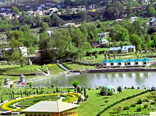
The climate of Doda remains calm and pleasant throughout the year. The best time to travel here is between March and November, because during this time the climate is good. Snowfall is a common problem during winter.
doda-district

➤How to reach Doda

➥The nearest airport to Doda is Srinagar International Airport, which is 281 km away. This airport is connected to many major cities like Mumbai and Delhi etc. Visitors can fly to the airport to reach Doda and hire the taxi.
➥The nearest railway station for Doda is Jammu Railway Station, which is 81 km away. This railway station connects destination to other Indian cities.
➥There are also many deluxe buses available in the state which transit from Srinagar and Jammu to Doda.

You can get more information @https://doda.nic.in/


Comments

Popular posts from this blog

Hamirpur- Popular district in Himachal Pradesh

Map of Hamirpur District Hamirpur is one of the twelve districts of the Indian state Himachal Pradesh . The headquarters of the district is situated in the Hamirpur town. This is the smallest district of Himachal Pradesh. This district has an area of 1118 square kilometers or we can say 432 square miles. This district is located between 31°25' N & 31°52' N and also between 76°18' E & 76°44' E. It is located at an altitude of 785 metres. It is bordered by district Mandi in the East, Bilaspur in the South, Una in the West & Kangra in the North. River Beas separates Hamirpur from Kangra district. ◆Hamirpur district is associated with the Katoch dynasty. Earlier it was a part of Jalandhar-Trigarta empire . Raja Hamir Chand build the fort at Hamirpur and present name of town was derived from this ruler. It is also known as Martyr's Land. ◆The climate of Hamirpur district was not very cold in winters as it is situated closer to plain ar

Jammu and Kahmir- The Paradise of Earth

Jammu & Kashmir Jammu and Kashmir is a state of India. It holds a special place around the world for its natural beauty. Jammu and Kashmir basically shares its borders in three areas i.e. it includes Kashmir Valley, Jammu and Ladakh. Jammu and Kashmir is a popular tourist attraction, so tourists can come here anytime to spend their holiday. Apart from the nature lovers, this place holds a special position in the heart of the enthusiasts engaged in adventure activities. The famous Mughal Emperor Jahangir, was always called the lion of this place. The emperor believed that if there is a paradise on earth then it is right here. Kashmir is one of the most beautiful places of the world, along with its magnificent mountain ranges, crystal clear stream, temple, glacier, and gardens make this place magnificent. Dal Lake ➤Languages ​​of Jammu and Kashmir The official language of the state of Jammu and Kashmir is Urdu which is written in Persian script and is widely

Kangra- A District in Himachal Pradesh

Map of Kangra District, Himachal Pradesh Kangra is a tourist spot located in Manjhi and Bener streams in Indian state Himachal Pradesh . Between the Dhauladhar Range and the Shivalik Range , this city is located in the Kangra valley and the Banganga stream is visible. It is also commonly known as Dev Bhoomi , which means the residence of Gods. According to the Vedas, various non-Aryan tribal communities lived here before the arrival of the Aryans. In the great Indian epic Mahabharata, Kangra has been referred to as a triangular state. Kangra city came under the rule of Muslims after the attack by Muhammad Ghazni in the 10th century. After this, the Katoch dynasty came under the rule of the oldest surviving dynasty. After the conclusion of the first Anglo-Sikh war, Kangra was captured by the British. In 1846, it became a district of colonial India. After the partition of India in 1947, it became a part of Punjab in 1947, but it was transferred to Himachal Pradesh in 1966.