Kinnaur- A peaceful district of Himachal Pradesh

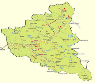
Kinnaur district himachal pradesh map
Map of Kinnaur District
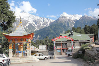
Located in the northeast of Himachal Pradesh, Kinnaur is a fascinating tourist destination. This beautiful place is about 250 km from Himachal's capital Shimla. Recong-Peo in front of Kinner Kailash, which is the headquarters of this district, is very beautiful. The area surrounded by high-rise snowy hills and green trees is divided into upper, middle and lower parts of Kinnaur. The border of this district, which is rich in natural beauty, is linked to Tibet, reaching here through the NH-22 by passing through mountain valleys is not less than travelling to a paradise.

The natural beauty of this place is known for snow-covered mountains, beautiful green valleys, mature gardens and lush vineyards. With this, there are several rivers and various species of flora and fauna. The difference in Kinnaur culture from the rest of this state can be seen, because it holds deep equality with Tibetan culture. There are two main valleys in the Kinnaur area-the Sangla Valley and the Hangrang Valley. The Sangla Valley is known for its beautiful gardens while the Hangrang Valley is famous for its greenery. Passengers can also see the vast Kinner Kailash Mountain, which is the most prominent attraction of this area. Apart from this, you can also go around the beautiful village of Kalpa, which is known for its natural beauty.

➤Main tourist destination of Kinnaur:

●Kalpa - Kalpa is a beautiful tourist spot located in Kinnaur District, in ancient times this place was the first district headquarters of the district Kinnaur. This place is located at an altitude of 3500 meters above sea level. From here, beautiful scenic views of the snowy mountains can be seen. Narayan Nagani temple is situated in the heart of the village, which reflects the local art here. Along with the tourist site, there are also many ancient Buddhist monasteries. This village is located infront of Kinnaur Kailash(about 2758 meters high). Kinnaur Kailash is considered the sacred place of Lord Shiva.

●Sangla - The attractive tourist destination of Kinnaur, Sangla, which is situated on the banks of river Baspa. This village is about 2900 meters above sea level. From this village, huge peaks of Raldang mountain are visible. Due to the beauty of green hills and snow covered peaks, it is beautiful tourism destination from other places. Due to the Baspa river flowing through this valley, this place is also called Baspa Valley.

●Chitkul - The last village of India is Chitkul, situated at an altitude of about 3450 meters above sea level. This village is the last and highest village of the Baspa valley. This place is located on the right side of the river Baspa. There are three temples of local goddess Mathi in this village. It is also a famous tourist destination.

●Nako - Located in Kinnaur, Nako is also a tourist spot. This place is situated at a distance of 100 km from Kalpa. It is also known as the Hangrang Valley. Located in the Hangrang Valley, this village is 3600 meters above sea level. There is also a natural religious lake in this village. There are many Buddhist monasteries and gompa.

➤How to Reach here:

●Shimla is the nearest airport to Kinnaur, which is 267 km from the town of Kalpa. Shimla Airport is connected to many major cities of India including New Delhi and Chandigarh.
●The nearest major railway station for Kinnaur is Shimla Railway Station, which is located approximately 244 km from the city.
●Regular buses for Kinnaur are available from nearby places such as Rampur and Shimla.

➤Best time to visit: 

The summer season (April to June)is the best time to visit Kinnaur. During Monsoon (July to September),there are great chances of rainfall so it is not very advisable to visit this place in Monsoon season. Winters in this area start from the month of October and continues till March, which keeps the weather very cold. During this time mercury levels can go below sub zero level. On the tour of Kinnaur, passengers are advised to carry heavy woolen cloth, this place remains cold throughout the year.

Know more about Kinnaur at their official site @https://hpkinnaur.nic.in/

Here are some images of this area.

baspa river view at chitkul himachal pradesh

view of village kalpa at himachal pradesh

view of kinnaur valley in himachal pradesh

nako lake at nako village himachal pradesh

view of nako village himachal pradesh

close view of nako lake himachal pradesh

recong peo hospital entry gate

view of sangla valley in himachal pradesh

Comments

  1. Marvelous work!. Blog is brilliantly written and provides all necessary information I really like this site. Thanks for sharing this useful post.
    https://www.bharattaxi.com

    ReplyDelete
    Replies
    1. Hello Ankita Singh, Thanks for your valuable comment. Please visit again for more new content.

      Delete

Post a Comment

Popular posts from this blog

Hamirpur- Popular district in Himachal Pradesh

Map of Hamirpur District Hamirpur is one of the twelve districts of the Indian state Himachal Pradesh . The headquarters of the district is situated in the Hamirpur town. This is the smallest district of Himachal Pradesh. This district has an area of 1118 square kilometers or we can say 432 square miles. This district is located between 31°25' N & 31°52' N and also between 76°18' E & 76°44' E. It is located at an altitude of 785 metres. It is bordered by district Mandi in the East, Bilaspur in the South, Una in the West & Kangra in the North. River Beas separates Hamirpur from Kangra district. ◆Hamirpur district is associated with the Katoch dynasty. Earlier it was a part of Jalandhar-Trigarta empire . Raja Hamir Chand build the fort at Hamirpur and present name of town was derived from this ruler. It is also known as Martyr's Land. ◆The climate of Hamirpur district was not very cold in winters as it is situated closer to plain ar

Jammu and Kahmir- The Paradise of Earth

Jammu & Kashmir Jammu and Kashmir is a state of India. It holds a special place around the world for its natural beauty. Jammu and Kashmir basically shares its borders in three areas i.e. it includes Kashmir Valley, Jammu and Ladakh. Jammu and Kashmir is a popular tourist attraction, so tourists can come here anytime to spend their holiday. Apart from the nature lovers, this place holds a special position in the heart of the enthusiasts engaged in adventure activities. The famous Mughal Emperor Jahangir, was always called the lion of this place. The emperor believed that if there is a paradise on earth then it is right here. Kashmir is one of the most beautiful places of the world, along with its magnificent mountain ranges, crystal clear stream, temple, glacier, and gardens make this place magnificent. Dal Lake ➤Languages ​​of Jammu and Kashmir The official language of the state of Jammu and Kashmir is Urdu which is written in Persian script and is widely

Bilaspur- Tourist Place in Himachal Pradesh

BILASPUR (HIMACHAL PRADESH) Map of Bilaspur District (H.P.) Bilaspur  is a district of the Indian state Himachal Pradesh . It is situated in  Shivalik  range of lower Himalayas. It is surrounded by mountains from all sides. It is bordered by  Punjab  (an Indian state) in south and west. There is fog along the banks of river Sutlej during winter season. Here summers are hottest in month of may and June. Rainy season is from early July to mid September.  This contains a man made Govind Sagar Lake. This lake acts as the reservoir of Bhakhra & Nangal Dam project. Its headquarters are situated in the town Bilaspur. The district has an area of 1167 square kilometers. According to 2011 census, its population is 3,82,056. Bilaspur district was formerly known as "kahlur". The ruler acquiesce in to the government of India on 12 October, 1948 & it was made an Indian state under a chief commissioner. The state of Bilaspur was merged with Himachal Pradesh on 1 July