Chamba- A district of Himachal Pradesh

chamba district map,
Map of Chamba District

Chamba is a district of the Indian state Himachal Pradesh. it is northwestern district of Himachal Pradesh. It is located at an altitude of 3268 ft. It is bounded on north west by Jammu, on north east by  Kashmir, east by ladakh,south east by lahaul & barabangal area & south by district Kangra of himachal pradesh & Gurdaspur district of Punjab. It is situated between latitude 32° 11′ 30” North and 33° 13′ 6” North and longitude 75°49' East and 77° 3′ 30” East. It has total area of 6522 square kilometer.

➤Chamba the land of lord Shiva. Dalhousie and khajjiar are the most popular hill stations of this district. There are five lakes, five wild life sanctuaries and countless number of temples.Thousands of people came here every year to spend their vacations.Its high Mountain ranges have given it a sheltered position and helped in preserving its centuries-old relics and many inscriptions. Its head quarters are in chamba town.In 2006 the Ministry of Panchayati Raj named Chamba one of the country's 250th most backward districts. This district currentlty receives the fund from BRGF(backward regions grant fund programme).
➤According to 2011 census the total population of Chamba district is 519080 & density is 80 per square kilometer. This population includes 261320 male & 257760 females. Its main language is Hindi. There are seven sub-divisions, thirteen tehsils & sub-tehsils, seven development blocks & three Municipalities. There are 1591 villages in this district.
➤There are many ways to reach here. You can reach  here by road through HRTC bus.
The nearest railway station is at Pathankot, approx. 120 Km from Chamba town. 
The nearest airport is at Pathankot. Other reachable air ports are Kangra(172 km approx.), Amritsar (220 km approx.) and Chandigrah(400 km approx.). 
For tourists, local transport are also available.
➤There are many places to visit. Some of them are The Chamba Chowgan , Laxmi Narayan Temple, Sui Mata Temple, Bhuri Singh Museum, Rock Garden at Devi Dehra, Kalatop, Dalhousie, Khajjiar etc. 

If you want to know more about this place then you can visit their official website https://hpchamba.nic.in/


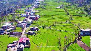
Here are some pictures of this district.


chamba images,

images of chamba, beautiful sceneries of chamba,

chamba images, chamba district images,

chamba district images, dalhousie images,

chamba images, switzerland of india, khajjiar images,

rivers in chamba,

lakes in chamba district, himachal pradesh lakes,

chamba images, himachal pradesh images,

Comments

Popular posts from this blog

Hamirpur- Popular district in Himachal Pradesh

Map of Hamirpur District Hamirpur is one of the twelve districts of the Indian state Himachal Pradesh . The headquarters of the district is situated in the Hamirpur town. This is the smallest district of Himachal Pradesh. This district has an area of 1118 square kilometers or we can say 432 square miles. This district is located between 31°25' N & 31°52' N and also between 76°18' E & 76°44' E. It is located at an altitude of 785 metres. It is bordered by district Mandi in the East, Bilaspur in the South, Una in the West & Kangra in the North. River Beas separates Hamirpur from Kangra district. ◆Hamirpur district is associated with the Katoch dynasty. Earlier it was a part of Jalandhar-Trigarta empire . Raja Hamir Chand build the fort at Hamirpur and present name of town was derived from this ruler. It is also known as Martyr's Land. ◆The climate of Hamirpur district was not very cold in winters as it is situated closer to plain ar...

Jammu and Kahmir- The Paradise of Earth

Jammu & Kashmir Jammu and Kashmir is a state of India. It holds a special place around the world for its natural beauty. Jammu and Kashmir basically shares its borders in three areas i.e. it includes Kashmir Valley, Jammu and Ladakh. Jammu and Kashmir is a popular tourist attraction, so tourists can come here anytime to spend their holiday. Apart from the nature lovers, this place holds a special position in the heart of the enthusiasts engaged in adventure activities. The famous Mughal Emperor Jahangir, was always called the lion of this place. The emperor believed that if there is a paradise on earth then it is right here. Kashmir is one of the most beautiful places of the world, along with its magnificent mountain ranges, crystal clear stream, temple, glacier, and gardens make this place magnificent. Dal Lake ➤Languages ​​of Jammu and Kashmir The official language of the state of Jammu and Kashmir is Urdu which is written in Persian script and is widely ...

Sirmaur, Himachal Pradesh || Himalayan High Hills

Sirmaur, Himachal Pradesh One of the natural treasures of Himachal Pradesh , Sirmaur is known as a bowl of Peach  (fruit). Located in the southeast of the state, this site was established in 1090 AD by King Rasalu of Jaisalmer. During the British period in India, this region has remained a princely state. At present Sirmaur is counted as one of the most special tourist destinations in Himachal Pradesh with its various natural sites. With the Himalayan landscape, Sirmaur invites all kind of tourists to come here. The friendly atmosphere here is considered ideal for a pleasant holiday. There are six tehsils in this district as Nahan, Renuka, Paonta Sahib, Rajgarh and Shillai. The Giri River divides this district into two equal parts that is Giripar and Giriwar. ➤Main Places of Interest in this Sirmaur district: ➥Churdhar You can start the journey of Sirmaur from the religious places here. Located at an elevation of 3,647 meters above sea level, it is one of the highe...