BILASPUR (HIMACHAL PRADESH)
 |
| Map of Bilaspur District (H.P.) |
This contains a man made Govind Sagar Lake. This lake acts as the reservoir of Bhakhra & Nangal Dam project. Its headquarters are situated in the town Bilaspur. The district has an area of 1167 square kilometers. According to 2011 census, its population is 3,82,056.
Bilaspur district was formerly known as "kahlur". The ruler acquiesce in to the government of India on 12 October, 1948 & it was made an Indian state under a chief commissioner. The state of Bilaspur was merged with Himachal Pradesh on 1 July, 1954 & became Bilaspur district.
The district is divided into three Tehsils : Ghumarwin, Bilaspur Sadar & Jhandutta.
Naina Devi is a sub-tehsil of Bilaspur Sadar. There are total of 957 villages in Bilaspur district.
Naina Devi is a sub-tehsil of Bilaspur Sadar. There are total of 957 villages in Bilaspur district.
The district has a population density of 850 per square metres.
Hindi, English & Bilaspuri dialect of Punjabi are the most widely spoken languages in this district.
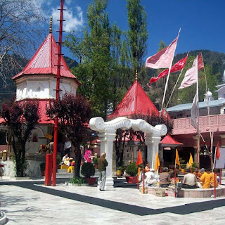
There are many places to to visit in Bilaspur district in which Govind Sagar lake, Naina Devi temple, Bandla hill for paragliding are most famous places.
Road transport is the main mode to travel in the district and there is no railway line or airport in the district.
For more information you can visit the official website of Bilaspur district at hpbilaspur.nic.in/
Here are some pictures of Bilaspur Distt. of Himachal Pradesh.
 |
| View from Naina Devi Temple |
 |
| View from Naina Devi |
 |
| Bandla Hill Paragliding |
 |
| Govind Sagar Lake |
 |
| Govind Sagar Lake |
 |
| Naina Devi Temple |
Hi Manish Diwakar, thanks for commenting here. Please visit my blog again for more updates.
ReplyDelete