Bilaspur- Tourist Place in Himachal Pradesh

BILASPUR (HIMACHAL PRADESH)


bilaspur map, himachal pradesh bilaspur map
Map of Bilaspur District (H.P.)
Bilaspur is a district of the Indian state Himachal Pradesh. It is situated in Shivalik range of lower Himalayas. It is surrounded by mountains from all sides. It is bordered by Punjab (an Indian state) in south and west. There is fog along the banks of river Sutlej during winter season. Here summers are hottest in month of may and June. Rainy season is from early July to mid September. 
This contains a man made Govind Sagar Lake. This lake acts as the reservoir of Bhakhra & Nangal Dam project. Its headquarters are situated in the town Bilaspur. The district has an area of 1167 square kilometers. According to 2011 census, its population is 3,82,056.
Bilaspur district was formerly known as "kahlur". The ruler acquiesce in to the government of India on 12 October, 1948 & it was made an Indian state under a chief commissioner. The state of Bilaspur was merged with Himachal Pradesh on 1 July, 1954 & became Bilaspur district.
The district is divided into three Tehsils : Ghumarwin, Bilaspur Sadar & Jhandutta.
Naina Devi is a sub-tehsil of Bilaspur Sadar. There are total of 957 villages in Bilaspur district.
The district has a population density of 850 per square metres.
Hindi, English & Bilaspuri dialect of Punjabi are the most widely spoken languages in this district.
There are many places to to visit in Bilaspur district in which Govind Sagar lake, Naina Devi temple, Bandla hill for paragliding are most famous places.
Road transport is the main mode to travel in the district and there is no railway line or airport in the district.
For more information you can visit the official website of Bilaspur district at hpbilaspur.nic.in/


Here are some pictures of Bilaspur Distt. of Himachal Pradesh.


naina devi, view from naina devi.
View from Naina Devi Temple

view point naina devi, naina devi,
View from Naina Devi

paragliding, bilaspur paragliding, bandla hill paragliding
Bandla Hill Paragliding

govind sagar, bilaspur lake, man made lake in bilaspur
Govind Sagar Lake

Govind sagar lake, bilaspur lake,
Govind Sagar Lake

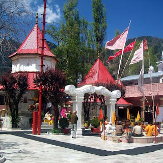
naina devi temple, naina devi pics,
Naina Devi Temple

Comments

  1. Hi Manish Diwakar, thanks for commenting here. Please visit my blog again for more updates.

    ReplyDelete

Post a Comment

Popular posts from this blog

Hamirpur- Popular district in Himachal Pradesh

Map of Hamirpur District Hamirpur is one of the twelve districts of the Indian state Himachal Pradesh . The headquarters of the district is situated in the Hamirpur town. This is the smallest district of Himachal Pradesh. This district has an area of 1118 square kilometers or we can say 432 square miles. This district is located between 31°25' N & 31°52' N and also between 76°18' E & 76°44' E. It is located at an altitude of 785 metres. It is bordered by district Mandi in the East, Bilaspur in the South, Una in the West & Kangra in the North. River Beas separates Hamirpur from Kangra district. ◆Hamirpur district is associated with the Katoch dynasty. Earlier it was a part of Jalandhar-Trigarta empire . Raja Hamir Chand build the fort at Hamirpur and present name of town was derived from this ruler. It is also known as Martyr's Land. ◆The climate of Hamirpur district was not very cold in winters as it is situated closer to plain ar...

Jammu and Kahmir- The Paradise of Earth

Jammu & Kashmir Jammu and Kashmir is a state of India. It holds a special place around the world for its natural beauty. Jammu and Kashmir basically shares its borders in three areas i.e. it includes Kashmir Valley, Jammu and Ladakh. Jammu and Kashmir is a popular tourist attraction, so tourists can come here anytime to spend their holiday. Apart from the nature lovers, this place holds a special position in the heart of the enthusiasts engaged in adventure activities. The famous Mughal Emperor Jahangir, was always called the lion of this place. The emperor believed that if there is a paradise on earth then it is right here. Kashmir is one of the most beautiful places of the world, along with its magnificent mountain ranges, crystal clear stream, temple, glacier, and gardens make this place magnificent. Dal Lake ➤Languages ​​of Jammu and Kashmir The official language of the state of Jammu and Kashmir is Urdu which is written in Persian script and is widely ...

Sirmaur, Himachal Pradesh || Himalayan High Hills

Sirmaur, Himachal Pradesh One of the natural treasures of Himachal Pradesh , Sirmaur is known as a bowl of Peach  (fruit). Located in the southeast of the state, this site was established in 1090 AD by King Rasalu of Jaisalmer. During the British period in India, this region has remained a princely state. At present Sirmaur is counted as one of the most special tourist destinations in Himachal Pradesh with its various natural sites. With the Himalayan landscape, Sirmaur invites all kind of tourists to come here. The friendly atmosphere here is considered ideal for a pleasant holiday. There are six tehsils in this district as Nahan, Renuka, Paonta Sahib, Rajgarh and Shillai. The Giri River divides this district into two equal parts that is Giripar and Giriwar. ➤Main Places of Interest in this Sirmaur district: ➥Churdhar You can start the journey of Sirmaur from the religious places here. Located at an elevation of 3,647 meters above sea level, it is one of the highe...